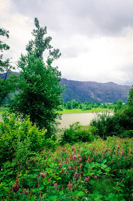
We decided to explore slightly further afield, and so we set off down the Columbia River Gorge. This is a natural border between the states of Oregon and Washington. We crossed the river at Vancouver, Washington (yes, that is confusing) and continued along the North bank. It really is quite spectacular.
Our first walk of the day took us up Beacon Rock. We dodged the rain and managed to hike up in a fine break in the weather. It's quite a popular track with many lookout points and good views.
This little fellow joined us at the top. He was very friendly and seemed to think that humans were invented to feed him. I thought it was a Blue Jay, but looking it up later, I suspect it is more like a Steller's Jay.
There are delightful waterfalls along the route, and many a shaded picnic spot.
A slight diversion took us to Backwoods Brewing Company for lunch. Located in Carson, its simple wooden furnishings and enormous serving sizes proclaim it is 'rustic'. Patronised by a plethora of folk in brushed cotton check shirts, it would also suit the term 'lumberjack' pretty well. Indeed, the menu features pizzas named Tree Hugger, 'Saw'sage Mill, The Spar Tree, and Timber Beast, amongst the usual suspects. We had a medium half and half of a Hungry Logger (pepperoni, sausage, black olives, Canadian bacon, red onions, green peppers, mushrooms) and a Bakin Chicken (bacon, chicken, white sauce, tomatoes, spinach, red onions). It was substantial.
 |
| Backwoods Brewing beers |
 |
| Images from The Dalles, Northwest Trading Center for 10,000 Years by Roger Cooke |
 |
| Celilo/ Wyam - The Great Falls on the Columbia by Robert Thomas |
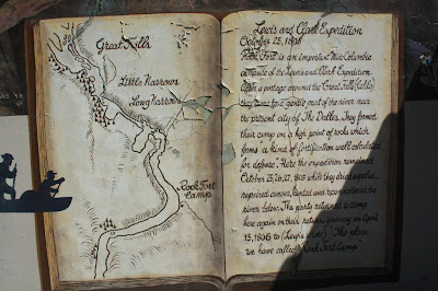
The Lewis and Clark Expedition (the first American expedition to cross the Western portion of the United States) portaged along the Columbia River around the Celilo Falls/ Wyam Falls/ Great Falls and then camped at a place they called Rock Fort in October 1805. The location formed 'a kind of fortification well calculated for defense' from which they dried supplies, repaired canoes, hunted and reconnoitered the river below.
 |
| Lewis and Clark at Rock Fort by Robert Thomas |
Starting in the 1810, the Americans and Europeans passed through what became The Dalles as they participated in the North Americn Fur Trade as employees of either the American Pacific Fur Company (PFC) or the Canadian North West Company (NWC). In 1821 the NWC was absorbed by the giant London-based Hudson's Bay Company (HBC).
 |
| Hudson Bay Company by Roger Cook |
The rapids of the Columbia River at The Dalles was the largest and longest of the four 'great portages' where fur trading boats had to unload and transport their cargoes. Sometimes, during high water, boats travelling downriver would 'shoot the rapids' instead of portaging, although this was very dangerous and many people died doing so.
In the early 1840s American settlers began to arrive after travelling overland on the Oregon Trail, which ended at The Dalles. The route further west was impassable due to steep cliffs that fell straight into the Columbia River. Until the construction of the Barlow Road in 1846, the only way to reach Fort Vancouver and the Willamette Valley was by rafting down the river from the Dalles. This scenario is captured in the mural Decision at The Dalles by Robert Crook.

Members of the Methodist-Episcopal church, Reverend Daniel Lee and Reverend H.K.W. Perkins arrived at The Dalles in 1838, with a mission to bring the word of God to the native people in Oregon. They called their new mission 'Wascopam Mission' named for the Wasco tribe living in the area, and it included preaching, prayer, teaching, translations, conversion, baptism, visitation and Christian comfort. During the period between 1838 and 1848 the area north of Pulpit Rock, at Amotan Springs, became the primary meeting and preaching location in the area.
 |
Rock of Ages (Pulpit Rock) by Hulan Fleming, assisted by Gary Bright |
 |
| Where Wheat is King by Robert Thomas |
The life of the Umatilla House was not always a scene of fine dining and gracious living. It suffered several tragic events that included two devastating fires: each time it burned to the ground. On both occasions it was rebuilt only to be damaged by the destructive flood of 1894. The once-proud hotel fell into disrepair during the early 1900's and was ordered to be destroyed by owner H.B. Salisbury in 1930.
 |
| Umatilla House 1857-1930 by Robert Thomas and Debbi Lunz |
These images are from another mural celebrating The Dalles' position as the end of the Oregon Trail. The mural is not officially part of the Dalles Mural Society's works, but I like the naif style.
Another 'unofficial' mural is this one regarding print activism in the 1950s and 60s. It relates to a fascinating tale of newspaper monopolies, strikes, picket lines, violence, dynamited vans and attempted murder. The Portland 'Newspaper Wars' became the third-longest newspaper strike in US history. It would make a really good plot for a film or a novel...
The Dalles is also famous for being the home of Chief, the narrator of Ken Kesey's One Flew Over the Cuckoo's Nest, and the location of the largest (and only) bioterror attack in U.S. history in 1984. A group of prominent followers of Bhagwan Shree Rajneesh (later known as Osho) deliberately contaminated salad bars at ten local restaurants with Salmonella, hoping to incapacitate the voting population of the city so that their own candidates would win the 1984 Wasco County elections. Seven hundred and fifty-one individuals suffered food poisoning and 45 were hospitalised, but no one died.
We began our way back to Portland along the south bank of the Columbia River, passing the Columbia Gorge Discovery Centre and Museum. It looked as though it probably housed many interesting exhibits, but we got there just as it was closing, so only really saw the outside.
Many of the picturesque waterfalls and traditional tourist spots are inaccessible due to devastating fires in September last year (started by 'an indigent teen' and causing over $37 million worth of damage). The scenic route is closed and the famous vistas are damaged beyond repair (for several hundreds of years at least), but there are still some pleasant roads to drive along and the lake to see. The classic viewpoint at Rowena Crest shows the road favoured by many a car company for its advertisements.
 |
| Rowena Crest Lookout |
Apparently the area at Hood River offers some of the best windsurfing in the world. It was certainly a popular spot with strong winds and big swells. We kept company with the birds who soared above looking down on the mere mortals below.
 |
| Hood River |
We stopped at Cascade Locks for an ice-cream. Well, that's what you do on holiday!
The town is named after a series of locks that were built along the Columbia River in 1896 to improve navigation past the Cascades Rapids. The locks were subsequently submerged in 1983 and replaced by Bonneville Lock and Dam.
Cascade Locks is at the lowest point of the Pacific Crest Trail (PCT), which runs from the Mexico-USA border in California to the USA-Canada border in Washington. It is also the largest 'city' directly on the route.
Cascade Locks is just upstream from the Bridge of the Gods, which spans the Columbia River and is frequently used by hikers along the PCT. It is a toll bridge, although it is free to pedestrians. The toll of $1 was raised to $2 in 2016 due to increased traffic after the film, Wild, made it popular with tourists. Drivers of cars displaying a 'local' sticker are still only charged $1.
In 1927 Charles Lindbergh flew The Spirit of Saint Louis over the bridge, before making a 180 degree turn and flying back beneath it.
 |
| The Bridge of the Gods |
Our final stop along the trip was to view the Columbia River Gorge from what would have been the gateway, if we had travelled the other way round, from The Portland Women's Forum Scenic Viewpoint. It was originally called Chanticleer Point, after the Chanticleer Inn, built here in 1912 and burned down in 1930.
The land was purchased by the Portland Women's Forum and donated to the Oregon State Parks and Recreation Department in 1962. The gift of the land was so that people could use it as a vantage point to 'overlook the great Columbia River, its magnificent canyon and the beautiful, green timbered mountains far to the north'. We did so.
Apparently, this view inspired railroad lawyer Samuel Hill and engineer Samuel Lancaster to 'conquer' the wild beauty of the gorge with a scenic drive. The first section of the route was opened in 1916, 'an engineering marvel and a craftsmen's showcase of hand-cut stone and elegant masonry'.
The first destination built along the new road was Vista House, originally built as a 'comfort station' for travellers. The Art Nouveau design with grey sandstone exterior and high-grade marble interior, brass fixtures and bronze-lined dome interior, was placed on the National Register of Historic Places in 1974, but when it was under construction it was widely derided by Oregonians as 'the $100,000 Outhouse'. Everyone's a critic...It is now a memorial to Oregon pioneers, but this area was sadly damaged in the Eagle Creek Fires and was inaccessible when we visited.


No comments:
Post a Comment